Dolly's remnants arrive tonight: 1 to 3 inches of rain Sunday into Monday over parched Puerto Rico
CoquiList · With information from NWS San Juan
The rain Puerto Rico has been waiting weeks for finally has an arrival date. Moisture from the remnants of Tropical Storm Dolly will begin pushing in from the east late Saturday night and drop 1 to 3 inches of rain between Sunday and Monday, with higher amounts in spots, according to the National Weather Service (NWS) in San Juan 12. But heads up: the heavy rain is not today. This Saturday the story is still heat, with a Heat Advisory in effect from 10:00 a.m. to 5:00 p.m. for coastal and urban areas of Puerto Rico, Vieques, Culebra and the Virgin Islands 1.
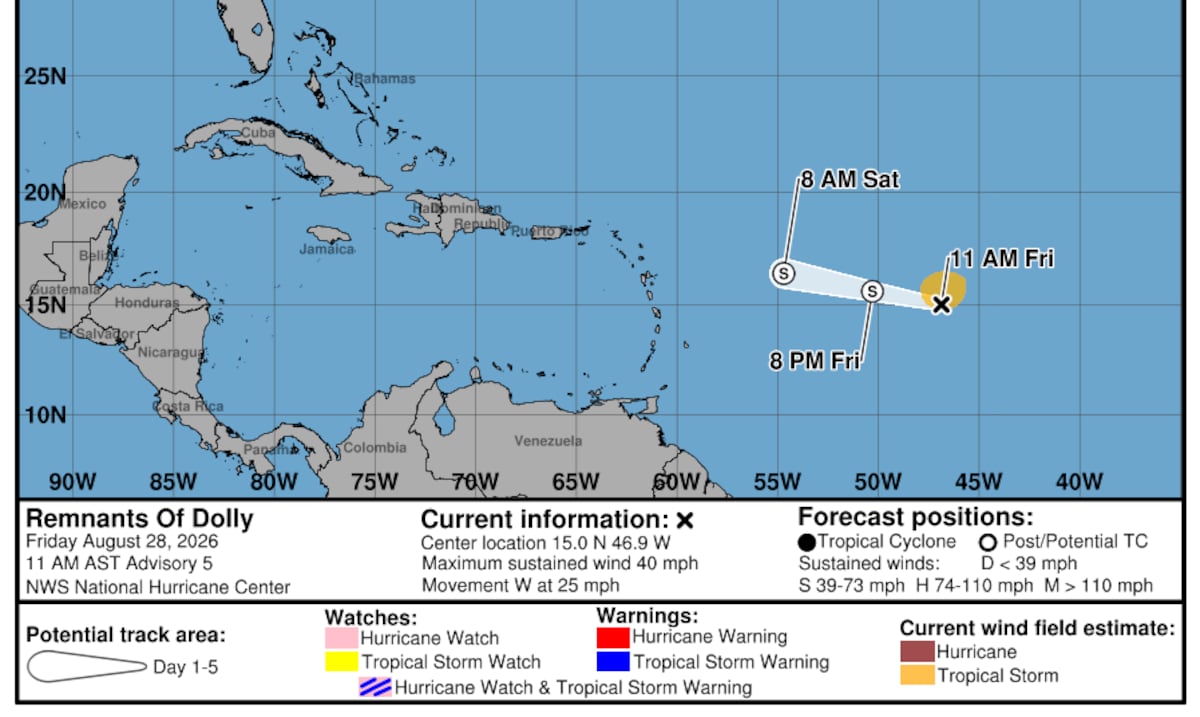
Dolly formed Thursday, August 27, in the central Atlantic, raising hopes it would deliver the first significant rain event in weeks for an island under severe to extreme drought 4. It did not last long as a cyclone: on Friday the 28th, the National Hurricane Center issued its final advisory as the system degenerated into an open tropical wave about 1,000 miles east of the Leeward Islands, racing west at 25 mph 34. Though it no longer has a name or a closed circulation, its load of moisture is still on the way and reaches the local Caribbean this weekend 23.
In its 3:28 a.m. discussion Saturday, the NWS laid out the sequence: today a drier air mass moves in, limiting showers to isolated afternoon activity in the west, with flood risk none to low 1. Starting late Saturday night, precipitable water values climb to between 2 and 2.5 inches 1. Showers and thunderstorms increase first over the U.S. Virgin Islands early Sunday, spread to Vieques, Culebra and eastern Puerto Rico between morning and midday, then expand across the rest of the island 1. The hydrologic outlook calls for general accumulations of 1 to 3 inches and a low to locally medium flood risk, with urban and poor-drainage flooding as the main threat, along with lightning and gusty winds 12. The risk of isolated flash flooding is lower, but cannot be ruled out 1. At sea, a Small Craft Advisory covers the Atlantic waters and the Anegada Passage Sunday into Monday, and a rip current risk runs from Sunday through Monday afternoon 1.
The question everyone is asking: does this end the drought. The NWS answer is blunt: no. The rain will be beneficial and bring temporary relief, but it will not be enough to end the severe to extreme drought punishing Puerto Rico and the Virgin Islands 12. With 1 to 3 inches spread over two days, the reservoirs will take in some water, but the summer's accumulated deficit is far larger.
What it means for you
Today, Saturday, the danger is heat: hazardous heat indices between 10:00 a.m. and 5:00 p.m. along coasts and in urban zones 1. Sunday into Monday the risk flips: if you live in an urban area with poor drainage, like parts of the metro area, expect deep ponding and flooded streets 12. The NWS warns that storm drains clogged with vegetation killed by the drought itself can worsen localized flooding 2. The upside: clouds and rain will lower temperatures Sunday and Monday, a brief break from the heat 1.
How to do it / Checklist
- Today, Saturday: hydrate, avoid the strongest sun from 10:00 a.m. to 5:00 p.m., and never leave children or pets in the car 1.
- Before tonight: clear drains, gutters and the storm grates in front of your home; accumulated dry vegetation clogs drainage 2.
- Secure loose objects on balconies and patios; gusty winds come with the thunderstorms 1.
- Sunday and Monday: do not cross flooded roads or bridges, on foot or by car.
- If you go to the beach, respect the rip current risk Sunday into Monday; mariners should heed the Small Craft Advisory 1.
- Capture rainwater if you have a cistern: this is one of the few usable rains in weeks.
- Follow NWS San Juan updates; forecast confidence is medium and totals may still change 2.
What's next
Dolly's lingering moisture could bring additional showers Tuesday, especially across the east and the metro area in the morning 12. Dangerous heat returns Wednesday, with indices that could reach 111 degrees along coastal and urban sections, and Thursday shapes up as the driest day of the week 1. Hurricane season remains active: Dolly was the fourth named storm of the year and will not be the last wave to watch.
Sources
CoquiList summary and local context. Read the linked sources for the original reporting.
Ask about this story
Ask anything about this article — in English or Spanish.
Log in to ask about this story.
Comments (0)
Log in to join the conversation.
No comments yet — be the first.